
Microplanning for Malaria Control
This week I’m in Nairobi to attend the Alliance for Malaria Prevention (AMP) meeting, where I will be joining other technology providers, malaria practitioners, and other stakeholders to advance the digitization of malaria campaigns across the world. I will be debuting some of our newest features, such as the Microplan Collector, to show how we work with countries across Africa to plan bednet distribution campaigns and indoor residual spraying campaigns. This article walks through a few of the key features I’ll be covering.
For Starters: What is Microplanning?
Microplanning is essentially a detailed, ground-level planning process that relies on field-level malaria practitioners to count households in affected areas and determine treatment approaches. This bottom-up method typically yields better results than top-down planning and is recommended by AMP. Microplanning is about breaking down broader strategic plans into actionable, localized steps.
The key difference between broad strategic planning and microplanning is that while strategic planning sets overall goals (like "reduce malaria transmission"), microplanning determines the precise, local-level actions needed to achieve those goals. It's the difference between deciding to distribute bed nets and figuring out exactly which households will receive them, when, and how.
While microplanning originated in global health programs, its principles of detailed geographic targeting and resource optimization are increasingly valuable across other sectors. Whether you're targeting malaria or mapping service delivery, the core concept of turning big-picture goals into specific, location-based actions stays the same.
The Microplanning Challenge in Malaria Control
Despite the billions invested, many malaria treatment programs still rely on hand-drawn maps and aged census data to plan and distribute these lifesaving interventions. Anyone who's worked on malaria, or almost any other tropical disease, knows the frustration of the planning process. It’s messy, expensive, and can sometimes feel like a best-guess effort.
One of the fundamental hurdles of microplanning is needing data that is not easily available and often costly to obtain. Whether you’re distributing insecticide-treated nets (ITNs) or conducting indoor residual spraying (IRS), you need to know quite a lot of information to get started:
- Which communities need to be targeted?
- How many households need to be reached?
- Does challenging terrain slow down service delivery?
- How many resources are required for complete coverage?
- How can you ensure no settlements are missed?
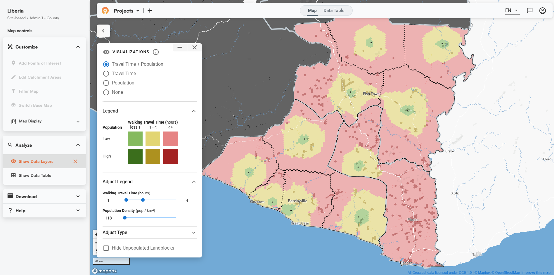
Simplifying Service Area Maps
As a partner on the PMI Evolve project (a global program for Malaria prevention), Crosscut helps put big data to work for countries that need simple service area maps for IRS campaigns and ITN distribution below the district level. While changes at USAID have dramatically shifted the landscape (more on that below), we're working directly with more and more Ministries of Health to ensure sustainable tech adoption.
The Crosscut app is free to use—that part won’t change. Through our ongoing partnerships, we’re helping program planners and teams combat Malaria in three important ways:
- Improve target population estimates through streamlined collection, aggregation, and analysis of microplans
- Estimate campaign resources needed through quantifications aligned with AMP guidance
- Reach more communities through clear delineation of operational boundaries below the district level.
What makes the Crosscut App different is that we've designed specific features for (and with) health program managers and planners, not GIS experts.
As Malaria prevention efforts in Ghana and Uganda show, you don't need specialized training to create accurate maps that account for real-world factors like travel time, population density, and physical barriers.
Beyond Maps: No-Code Supply Planning
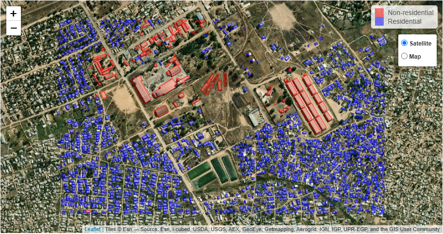
As part of the PMI Evolve project, we supported the Ghana and Uganda field offices to pilot test our IRS supply planning module. Mainly because it solves a key issue for program planners: ordering the right amount of insecticide, you need to know how many structures you’ll spray and how big they are. With their direct guidance, that's what we built.

Through hands-on design sessions and field testing, we adapted the Crosscut App to generate catchment areas for each IRS operational site and established a basic calculator to quantify the various supplies, insecticides, and human resources needed for the campaign. This feature analyzes satellite imagery to measure building sizes in each catchment area, helping teams order just the right amount of insecticide for their spraying campaigns.
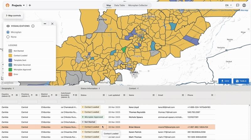
Email to Excel: Making Microplanning Less Painful
Most recently, we've also tailored our Microplan Collector module to support malaria campaigns, built to follow AMP guidance on microplanning to the letter. Having seen how teams struggle with endless email chains and version control nightmares, we built a tool that simplifies the entire field data collection process.
This feature lets program managers:
- Send microplanning templates out via email
- Track which implementation units have completed their plans
- Automatically flag unusual data that might indicate errors
- Easily compile everything into a master plan
- Download an Excel supply plan estimating the resources needed for the campaign
Rather than introducing new technology into an already crowded ecosystem, the Crosscut App allows you to continue using email and Excel just as you do today while still benefiting from streamlined collection and aggregation of data. We designed it this way because over 90% of microplanning still happens through Excel spreadsheets being emailed back and forth.
But don’t worry: our app integrates directly with DHIS2 and you can migrate your estimates from the Crosscut App directly into DHIS2 for further usage!

Adapting to a Changing Landscape
With the recent changes at USAID, we're hoping to adapt our approach to support more and more Ministries of Health directly. Our technology is designed to be require little to no training and will continue to be available to country teams even as funding environments shift, as they are doing right now.
The Crosscut App remains free to use, particularly in the 43 countries where we've already enabled detailed catchment mapping. We're committed to keeping it that way.
Come Say Hello in Nairobi
If you're attending the AMP meeting in Nairobi this week, stop by our booth during the Campaign Digitalization sessions. I’d love the opportunity to learn about your microplanning challenges and discuss how they might fit your specific needs.
Can't make it to Nairobi? Not to worry. You can contact us anytime. Our team is always available to help you get started. For organizations with more complex needs, our advisory services provide custom development support to optimize your planning processes.
Related Posts
Loamin x Crosscut: Modernizing Malaria Prevention with Geospatial Maps


How AI Is Impacting Our Work
.JPG)
Microplanning with Email and Excel
